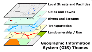
I am learning some new GIS software from ESRI. While I am not the best programmer, I do understand the basics of SQL and other easy programming stuff so I figured this would not be a major feat. I was wrong. I am learning the new field of spatial epidemiology and using GIS software to track diseases and epidemics. I am finding two problems. First the issue of importing information. I am transferring data from one format (usually SAS) into the Arc/GIS format. A few years ago the two companies created a SAS/GIS bridge but I found it very user unfriendly and shyed away from using GIS because many datasets I work with are SAS. Being an astute epidemiologist (ok, you can laugh) I have to make sure data is not lost or transformed. So I can spend ooodles of time doing Q and A. This year they improved it drastically and little work has to be done to get the data from point A to B. So that is a plus! Secondly, I learned in my class that using classical statistical tools to analyze spatial data do not apply. In fact, they can be grossly inaccurate and down right misleading. SO I have to learn NEW statisical methods and new standard coefficients. There are books devoted to statistical analyses of spatial data. Greaaattt...more books to buy!
The idea sounds exciting but the exeuction is very hard and I am getting quite frustrated. I will just have to learn it, as this will eventually become a standard tool and I have no doubt the MPH students entering this year will have to learn it.
Now I know how all the old folks felt when they had to learn Windows. Sheesh!
Friday, January 27, 2006
GIS
Posted by KMP at 6:05 AM
Subscribe to:
Post Comments (Atom)

2 comments:
Hey Girl
Feel free to email me if you need help, after 3 years of ESRI tech support I"ve seen it all.
You can be my teachers pet
I,m glad your having difficulties!
I,m an oldie and just starting to learn this modern day contraption and find it exceedingly difficult. Why does modern life have to be so difficult?
Post a Comment